![](/images/other/stat-length.png)
![Randonnée Marche Le Gâvre - Forêt du havre - Photo](https://media.geolcdn.com/t/1900/400/ext.pjpeg?maxdim=2&url=https%3A%2F%2Fstatic1.geolcdn.com%2Fsiteimages%2Fupload%2Ffiles%2F1553511878bg_sport_marche.png)
Forêt du havre
PhilippeLegault
Utilisateur
![Longueur](/images/other/stat-length.png)
Longueur
12,9 km
![Altitude max](https://static1.geolcdn.com/siteimages/upload/files/1508320355ic_sort_altitude_max_24dp.png)
Altitude max
53 m
![Dénivelé positif](https://static1.geolcdn.com/siteimages/upload/files/1508320355ic_sort_den_pos_24dp.png)
Dénivelé positif
112 m
![Km-Effort](/images/other/stat-length.png)
Km-Effort
14,4 km
![Altitude min](https://static1.geolcdn.com/siteimages/upload/files/1508320355ic_sort_altitude_min_24dp.png)
Altitude min
22 m
![Dénivelé négatif](https://static1.geolcdn.com/siteimages/upload/files/1508320355ic_sort_den_neg_24dp.png)
Dénivelé négatif
112 m
![Boucle](https://static1.geolcdn.com/siteimages/upload/files/16400158638029165_repeat_loop_refresh_sync_direction_icon.png)
Boucle
Oui
Date de création :
2020-07-08 08:34:08.0
Dernière modification :
2020-07-08 12:36:39.824
![Marche](https://static1.geolcdn.com/sitytour/trail-icons/101.png)
3h15
Difficulté : Facile
![Scannez ce code QR pour ouvrir la randonnée dans l'application SityTrail](https://capi.geolives.com/qq0zvz2zws4bq2lad0pu/sitytour/trails/2466877/qr.png?size=200)
Application GPS de randonnée GRATUITE
À propos
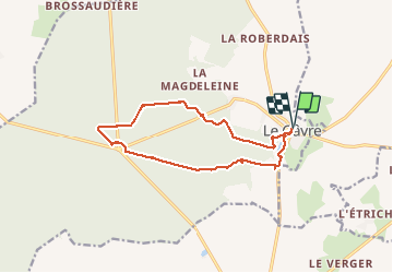
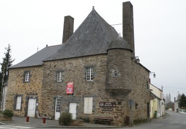
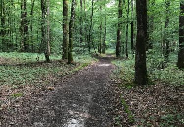
Randonnée Marche de 12,9 km à découvrir à Pays de la Loire, Loire-Atlantique, Le Gâvre. Cette randonnée est proposée par PhilippeLegault.
Description
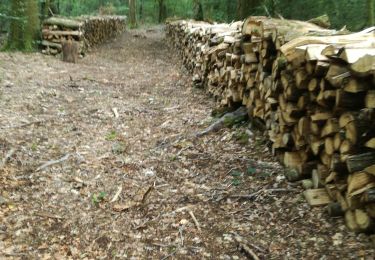
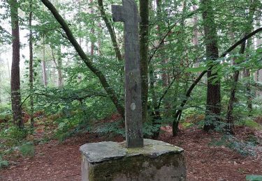
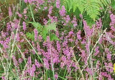
Sentier très ombragé l’été. La fin du parcours à partir du ruisseau est particulièrement sauvage.
Tables de pique-nique à la belle étoile.
Localisation
Pays :
France
Région :
Pays de la Loire
Département/Province :
Loire-Atlantique
Commune :
Le Gâvre
Localité :
Unknown
Départ:(Dec)
Départ:(UTM)
594290 ; 5263843 (30T) N.
Commentaires
Randonnées à proximité
![Randonnée A pied Le Gâvre - Le Chêne de la Messe - Photo](https://media.geolcdn.com/t/375/260/07e3cf84-6a15-410b-8836-4f65b56c35a6.jpeg&format=jpg&maxdim=2)
![A pied A pied](https://static1.geolcdn.com/sitytour/trail-icons/100.png)
Le Chêne de la Messe
A pied
Facile
Le Gâvre,
Pays de la Loire,
Loire-Atlantique,
France
![](/images/other/stat-length.png)
6,6 km | 7,5 km-effort
1h 42min
![](https://static1.geolcdn.com/siteimages/upload/files/16400158638029165_repeat_loop_refresh_sync_direction_icon.png)
Oui
![Randonnée Marche Le Gâvre - 7.8.2019 Forêt du Gavre - Photo](https://media.geolcdn.com/t/375/260/f9cf14e8-928c-443f-a037-337d0befb490.jpg&format=jpg&maxdim=2)
![Marche Marche](https://static1.geolcdn.com/sitytour/trail-icons/101.png)
7.8.2019 Forêt du Gavre
Marche
Moyen
Le Gâvre,
Pays de la Loire,
Loire-Atlantique,
France
![](/images/other/stat-length.png)
22 km | 25 km-effort
7h 48min
![](https://static1.geolcdn.com/siteimages/upload/files/16400158638029165_repeat_loop_refresh_sync_direction_icon.png)
Oui
![Randonnée Marche Le Gâvre - forêt du Gavre - Photo](https://media.geolcdn.com/t/375/260/9b5efb39-468e-45dd-bfa8-e0594305ea10.jpg&format=jpg&maxdim=2)
![Marche Marche](https://static1.geolcdn.com/sitytour/trail-icons/101.png)
forêt du Gavre
Marche
Moyen
Le Gâvre,
Pays de la Loire,
Loire-Atlantique,
France
![](/images/other/stat-length.png)
7,6 km | 8,6 km-effort
2h 45min
![](https://static1.geolcdn.com/siteimages/upload/files/16400158638029165_repeat_loop_refresh_sync_direction_icon.png)
Oui
![Randonnée Marche Le Gâvre - 07.08.2019 - GÂVRE nord et Clégreuc - Photo](https://media.geolcdn.com/t/375/260/50e63918-d990-4d20-974b-f7cef55e5682.jpg&format=jpg&maxdim=2)
![Marche Marche](https://static1.geolcdn.com/sitytour/trail-icons/101.png)
07.08.2019 - GÂVRE nord et Clégreuc
Marche
Moyen
Le Gâvre,
Pays de la Loire,
Loire-Atlantique,
France
![](/images/other/stat-length.png)
24 km | 27 km-effort
8h 8min
![](https://static1.geolcdn.com/siteimages/upload/files/16400158638029165_repeat_loop_refresh_sync_direction_icon.png)
Oui
![Randonnée Cheval Le Gâvre - gavre072016 - Photo](https://media.geolcdn.com/t/375/260/ext.jpg?maxdim=2&url=https%3A%2F%2Fservices.sitytrail.com%2FGeolivesWS%2FDownloadMedia.ashx%3FTrailID%3D606974%26Media%3Dfix__20160701105728.jpg)
![Cheval Cheval](https://static1.geolcdn.com/sitytour/trail-icons/300.png)
gavre072016
Cheval
Très facile
Le Gâvre,
Pays de la Loire,
Loire-Atlantique,
France
![](/images/other/stat-length.png)
32 km | 36 km-effort
4h 36min
![](https://static1.geolcdn.com/siteimages/upload/files/16400158638029165_repeat_loop_refresh_sync_direction_icon.png)
Oui
![Randonnée Cheval Le Gâvre - gavre juillet 2016 - Photo](https://media.geolcdn.com/t/375/260/ext.jpg?maxdim=2&url=https%3A%2F%2Fservices.sitytrail.com%2FGeolivesWS%2FDownloadMedia.ashx%3FTrailID%3D591466%26Media%3Dfix__20160701164833.jpg)
![Cheval Cheval](https://static1.geolcdn.com/sitytour/trail-icons/300.png)
gavre juillet 2016
Cheval
Très facile
Le Gâvre,
Pays de la Loire,
Loire-Atlantique,
France
![](/images/other/stat-length.png)
31 km | 35 km-effort
4h 31min
![](https://static1.geolcdn.com/siteimages/upload/files/16400158638029165_repeat_loop_refresh_sync_direction_icon.png)
Oui
![Randonnée Voiture Le Gâvre - 2024-12-21 Le Gavre RB - Photo](https://media.geolcdn.com/t/375/260/ext.jpg?maxdim=2&url=https%3A%2F%2Fstatic1.geolcdn.com%2Fsiteimages%2Fupload%2Ffiles%2F15247431544x4.jpg)
![Voiture Voiture](https://static1.geolcdn.com/sitytour/trail-icons/401.png)
2024-12-21 Le Gavre RB
Voiture
Le Gâvre,
Pays de la Loire,
Loire-Atlantique,
France
![](/images/other/stat-length.png)
40 km | 45 km-effort
3h 50min
![](https://static1.geolcdn.com/siteimages/upload/files/16400158638029165_repeat_loop_refresh_sync_direction_icon.png)
Non
![Randonnée Voiture Le Gâvre - 2024-10-29 RB l eGavre - Photo](https://media.geolcdn.com/t/375/260/ext.jpg?maxdim=2&url=https%3A%2F%2Fstatic1.geolcdn.com%2Fsiteimages%2Fupload%2Ffiles%2F15247431544x4.jpg)
![Voiture Voiture](https://static1.geolcdn.com/sitytour/trail-icons/401.png)
2024-10-29 RB l eGavre
Voiture
Le Gâvre,
Pays de la Loire,
Loire-Atlantique,
France
![](/images/other/stat-length.png)
24 km | 26 km-effort
2h 41min
![](https://static1.geolcdn.com/siteimages/upload/files/16400158638029165_repeat_loop_refresh_sync_direction_icon.png)
Oui
![Randonnée Marche Le Gâvre - Le Gavre - Photo](https://media.geolcdn.com/t/375/260/e88394df-1574-4bf1-962f-7b528c0be0ae.jpg&format=jpg&maxdim=2)
![Marche Marche](https://static1.geolcdn.com/sitytour/trail-icons/101.png)
Le Gavre
Marche
Moyen
Le Gâvre,
Pays de la Loire,
Loire-Atlantique,
France
![](/images/other/stat-length.png)
8,6 km | 9,7 km-effort
2h 58min
![](https://static1.geolcdn.com/siteimages/upload/files/16400158638029165_repeat_loop_refresh_sync_direction_icon.png)
Oui